Geospatial Data Scientist & Full-Stack Geospatial Engineer

Architecting Scalable Geospatial Data Systems for Climate, Disaster Risk, Humanitarian & Environmental Intelligence

More About Me

About Me


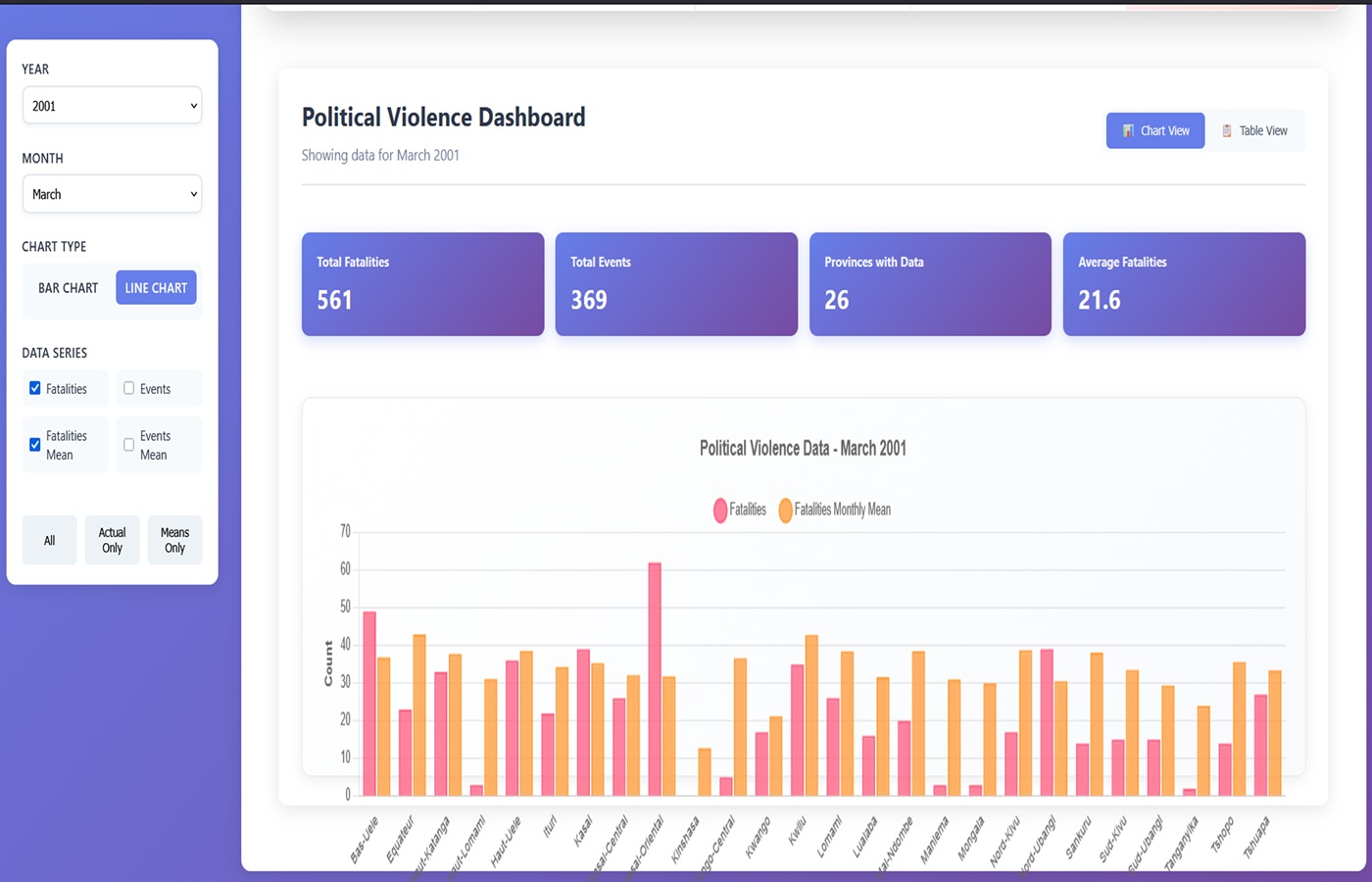
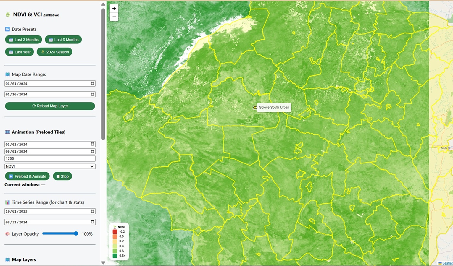
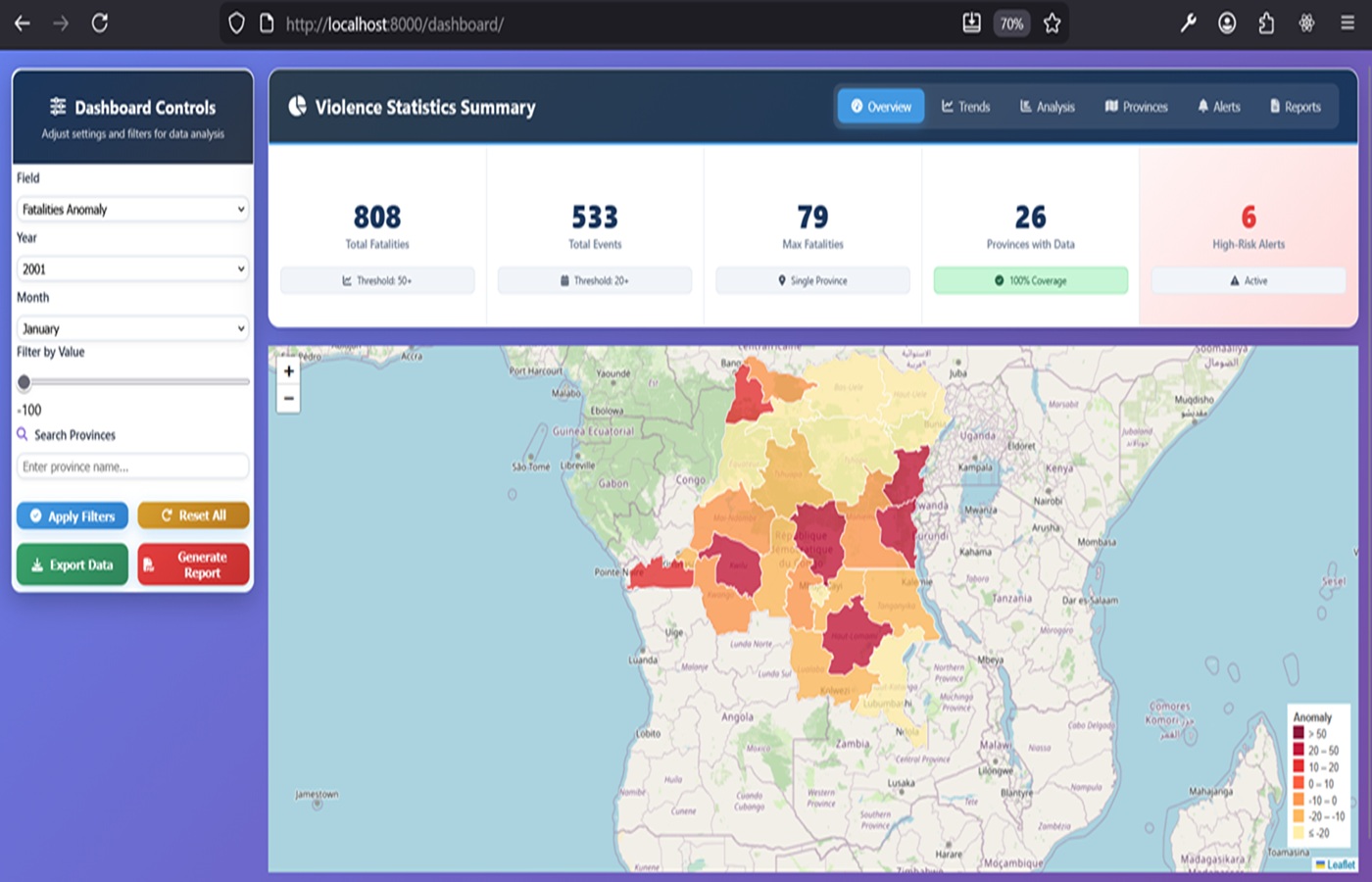
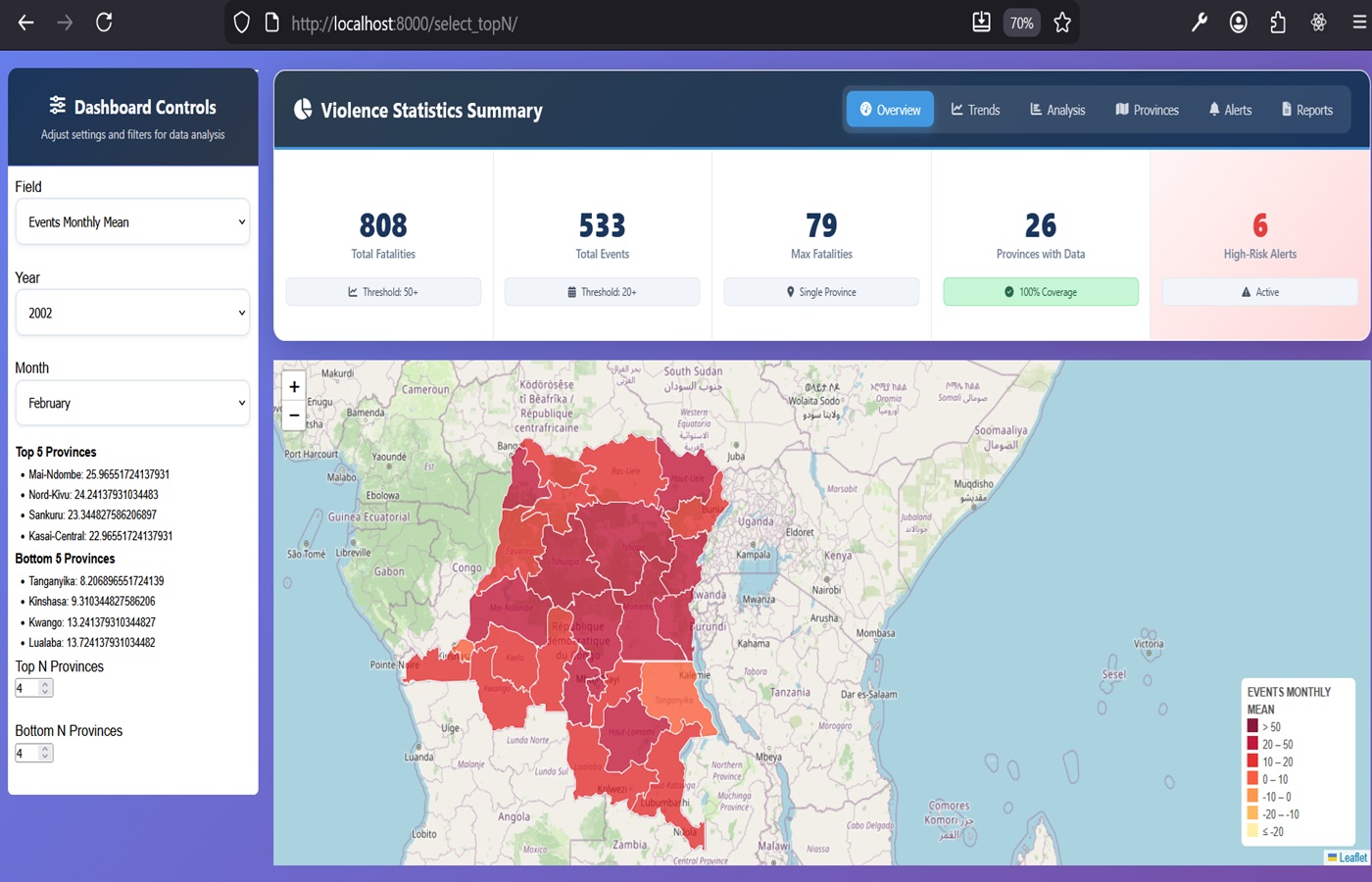
Geospatial Data Scientist and Earth Observation Systems Architect with 17+ years of experience designing and operationalizing satellite-driven decision-support systems for climate risk, disaster risk reduction, and humanitarian intelligence. Complemented by 4+ years of full-stack geospatial engineering experience, I specialize in translating complex Earth observation and environmental datasets into scalable, API-driven geospatial infrastructures and operational intelligence platforms. I have led the design of national and regional early warning systems for droughts, floods, and food insecurity across Africa, working with organizations including UNICEF, WFP, World Bank, FAO, African Union Commission, EU, and SADC. My expertise spans end-to-end geospatial system development—from satellite data processing and geospatial ETL pipelines to cloud-based analytics platforms, REST APIs, and interactive decision-support dashboards. Technically, I combine Google Earth Engine, Python, R, and machine learning with modern geospatial engineering stacks (PostGIS, Django/Flask/FastAPI, GeoServer, Leaflet, and Docker) to deliver scalable, production-ready Earth observation systems. My work focuses on transforming geospatial intelligence into actionable insights for policy, humanitarian response, and climate adaptation. Selected for the FAO Consultancy Roster (2025–2028) as a Remote Sensing & GIS Specialist, I continue to support international programs focused on climate resilience, anticipatory action, and geospatial digital transformation.

Profile

Engineering Earth Observation Systems for Climate Intelligence, Risk Monitoring & National Decision-Making

  • Full Name:

    Farai Maxwell Marumbwa

  • Birth Date:

    April 12, 1983

  • Current Position:

    Geospatial data analyst consultant

  • Website:

    https://github.com/maxmarumbwa

  • Email:

    maxmarumbwa@gmail.com

Technical Skills

Earth Observation & Geospatial Intelligence
  • Satellite data processing and analysis (MODIS, CHIRPS, ERA5, Landsat, Sentinel)
  • Earth Observation systems for drought, flood, vegetation, climate monitoring, and humanitarian applications
  • Machine learning for remote sensing classification and predictive modeling
  • Google Earth Engine (advanced scripting, cloud geoprocessing, automation workflows)
  • Python & R for automated GIS analysis
Full-Stack Geospatial Systems Development
  • Backend & APIs: Django, Flask, FastAPI, Django REST Framework, Node.js
  • Frontend geospatial applications: Leaflet, HTML, CSS, Bootstrap, Javascript, React
  • Map Services: GeoServer (WMS/WFS), tiled rasters
  • DevOps & Cloud: Git, GitHub, Docker
Data Engineering & ETL
  • Geospatial ETL pipeline development (Python, GeoPandas, Pandas, SQL, R)
  • Geospatial REST API development
  • Geodatabase: PostgreSQL/PostGIS, MongoDB, MySQL
  • Automation of analytics-ready datasets for web maps & decision-support systems
Core Technologies:
Python, ArcPy, NumPy, Geopandas, xarray R JavaScript Postgres/PostGIS, MongoDB Django GeoServer GEE QGIS Docker AWS Azure Git/GitHub Gdal google earth engine leaflet Nodejs Tableau / PowerBI / R shinny linux

Portfolio


Featured Projects

Click image to view app screenshots
Political Violence Dashboard

Full-stack analytics system for early warning and humanitarian planning.

Launch App View Code
Click to view project screenshots
AgroClimate Intelligence Dashboard

Geospatial platform for climate risk and agriculture monitoring.

Launch App View Code

Consulting Services


Geospatial Intelligence & Earth Observation Solutions

I design and implement end-to-end geospatial intelligence systems that transform Earth observation data, climate information, and socio-economic datasets into operational decision-support platforms for governments, humanitarian agencies, and development partners.

Earth Observation & Climate Analytics


Development of satellite-based monitoring systems for drought, floods, vegetation health, and climate variability. I build automated pipelines using Google Earth Engine, Python, and R to generate operational indicators such as NDVI, SPI, rainfall anomalies, and agricultural stress metrics.

Early Warning & Risk Intelligence Systems


Design of multi-hazard early warning systems integrating geospatial thresholds, anomaly detection, and automated alerts. These systems support anticipatory action frameworks for droughts, floods, food insecurity, and conflict risk monitoring.

Geospatial Data Engineering & APIs


Architecture of scalable geospatial data infrastructures including ETL pipelines, spatial databases (PostGIS), and REST APIs (Django, Flask, FastAPI). I convert raw satellite and climate data into analysis-ready systems for real-time web applications and dashboards.

Decision Support & Geospatial Dashboards


Development of interactive GIS dashboards using Leaflet, GeoServer, and modern web frameworks. These systems enable real-time monitoring, spatial analysis, and visualization for humanitarian response, agriculture, and environmental management.

Climate & Environmental Impact Assessment


Spatial analysis of environmental change, land degradation, and climate impacts using remote sensing and geospatial modeling. I support vulnerability assessments, impact evaluation, and evidence generation for climate adaptation planning.

Humanitarian Data & Information Systems


Design of integrated humanitarian data platforms for NGOs and international organizations. Includes needs assessment systems, response monitoring dashboards, and interoperability frameworks aligned with global humanitarian standards (SPHERE, UN, SADC frameworks).

Contact


Let’s Work Together

Have a geospatial, climate or humanitarian data project? Send a message and I’ll respond shortly.